Table of Contents
Learn how Victoria Falls was formed
If you have ever been to Zimbabwe, you have probably wondered, “How was Victoria Falls formed?” There are many reasons for this wonder, from geology to erosion. Let’s look at each of these reasons and see how they relate to how Victoria Falls formed.
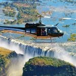
You will be amazed by the natural beauty of this waterfall!
Let’s get started! – What are the Origins of Victoria Falls? – Formation and Erosion.
Origins
The first known settlement around Victoria Falls is thought to be 3 million years ago. Humans made stone tools in this region, and later migrated to the area. At the same time, the Khoisan and Bantu tribes moved to the area. These peoples called the falls Shungu na mutitima and Mosi-oa-Tunya. Later, David Livingstone’s expedition named the falls Victoria Falls.
The Falls became an international tourist destination during the British colonial period, and the town of Victoria Falls grew up on the Zimbabwean side. Then, however, Zimbabwe and Zambia had conflict, and visitor numbers dropped. After the Rhodesian Bush War, Zambia imposed travel restrictions and stationed soldiers at the falls. During this period, many tourists opted to visit the Zambian side of the Falls. Fortunately, the country ended up re-opening the border and allowing visitors to experience the natural wonder.
The first Europeans to see the Falls were probably the Voortrekker hunters and Arab traders. Later, European explorers began to arrive in the region. In 1855, Dr David Livingstone wrote about the falls, saying that they were unlike anything he’d seen in England. After that, the area became known as Old Drift, and people began to settle in the area. After that, Cecil John Rhodes and his British-born son, Cecil, made it their mission to explore the region and bring back gold and silver.
Geology
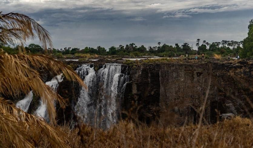
Geologists know that the formation of Victoria Falls is the result of the gradual erosion of the land by water. The geological process that erodes the rock at a waterfall produces a gorge. In this case, the gorge forms at the base of the waterfall. The force of the falling water erodes the softer rock, cutting into the earth to create a deep chasm with steep sides. The waterfall itself is formed by large cracks in the solidification of basalt, which were filled by softer sandstone over time.
The falls’ height causes them to plunge into a narrow gorge, which varies in width from eighty to 240 feet. The gorge outlet is a narrow channel cut into the barrier wall. The gorge is about 65 metres wide and three hundred meters long and holds the entire Zambezi River. This allows visitors to see the spray plume from a distance of fifty kilometers or thirty kilometers from the Bulawayo road.
As a result, the river flow at the Victoria Falls varies during different seasons. The river flows significantly lower from September to December. This phenomenon was so severe that National Geographic declared the falls endangered by 2020. Regardless of the cause of the falls’ decline, a visit to the Victoria Falls region is sure to leave a lasting impression on visitors. The Geology of Victoria Falls
Formation
The formation of Victoria Falls is a complex process. It is the latest manifestation of seven older falls that were once buried by the sandstone bedrock. Understanding the processes involved in Victoria Falls’ formation requires a thorough understanding of the area’s geology and ancient tectonic processes. Basalt, the rock that forms the bedrock beneath the Victoria Falls, is approximately 180 million years old. It can be as thick as 300 meters, making the region a geological island.
The river Zambezi, which originates in Namibia, flows over the cliff and into a narrow chasm about 1,700 metres below. As the water falls over the cliff, it forms the largest curtain of falling water in the world. The water falls over the chasm at different heights, ranging from 70 to 108 meters. In 1958, the falls reached a record flow of more than 700 000 cubic meters per minute, causing the gorges to rise eighteen meters above flood level.
The Victoria Falls are made up of five separate waterfalls: the Devil’s Cataract, Rainbow Falls, Horseshoe Falls, and Main. Three of these falls are located in Zambia and two are in Zimbabwe. The Devil’s Cataract is 70 meters high, and got its name from the adjacent island. Native tribes used to perform sacrificial ceremonies here, which missionaries referred to as “devilish”.
Erosion
The formation of the Victoria Falls can be traced to the gradual erosion of rock. The river used an east-west weakness to gradually cut the rock, creating a waterfall across its bed. As it eroded upstream, the river collected more water, creating a narrower section of the gorge. The resulting gorge was gradually filled with softer sandstone, which subsequently fell back into the bed and formed the broad fall.
The water flowed down the river in a southerly direction, exploiting the weak points in the basalt rock. As it eroded the rock, broad and deep east-west gorges were formed. The gorges were carved out by the huge water flow that had been concentrating over Victoria Falls. The resulting gorges had a greater depth than the previous falls, which made the Victoria Falls look even bigger.
The Zambezi River carved a path through the plateau by slowly eroding the rock. In doing so, the river pushed the current waterfall upstream eight kilometers. At the same time, it formed deep gorges. This is the cause of Victoria Falls’ current shape. As the Zambezi River eroded the plateau, it created a series of fractures in the rock. These cracks were filled with sandstone, which allowed the river to form Victoria Falls today.
Discovery
The Discovery of Victoria Falls dates back to 1855 when a Scottish explorer named David Livingstone crossed the Zambezi River. In 1855, he was escorted to a waterfall called Sesheke, and he witnessed the power and beauty of the waterfall, which he named after Queen Victoria of England. Today, visitors can admire the majestic waterfall that cascades at a rate of 150 million gallons per minute.
After his visit to the falls, Livingstone set out to explore further upriver to the mouth of the Zambezi River. Livingstone was fascinated by the sight of the Ngonye Falls, so he gave the falls their English name in honour of Queen Victoria. The next step involved mapping the Zambezi River and navigating upriver into the Barotse floodplains. The discovery of Victoria Falls was not complete until Livingstone returned to Linyanti, the village on the edge of the Zambezi River.
While a single entry visa permits entry to either side of the falls, it is possible to make day trips from one side to the other. Visitors should be aware of the requirement to obtain a visa for the Zimbabwean side. Visas cost approximately US$45. As of 01 December 2013, visitors must have a valid passport to cross the border. As a World Heritage site, it is important to note that the regulations for visas change frequently.
Names
There are many different names for Victoria Falls. The first European to visit the falls was David Livingstone, who named them after Queen Victoria. The local Lozi tribe gave them other names, including Thundering smoke, until the 19th century. However, archaeological sites in the area suggest that humans lived in the region at least three million years ago. Livingstone’s name was used as a tribute to the British monarch. Livingstone died shortly after naming the falls Victoria, which is the current official name for the Falls.
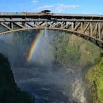
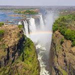
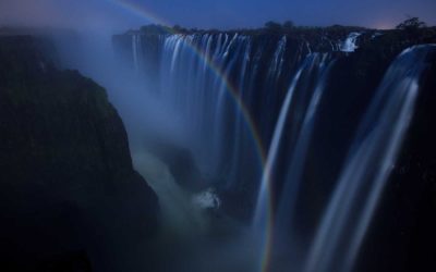
Local people refer to the Falls by many different names. “Mosi-oa-tunya” is one of these names, which means “smoke that thunders” in Lozi and Kololo languages. The falls are also known for rainbows, and you can view them most often during a full moon. The water is so powerful that it actually floods over the escarpment, causing the famous moonbow to form.
The waterfall is not the highest nor the widest waterfall in the world, but it is the largest sheet of falling water. It is twice the height and width of Niagara Falls and is only rivaled by Iguazu Falls in Argentina. The Victoria Falls are situated on the Zambezi River, which spans six countries. It is the boundary between the upper and middle stretches of the Zambezi. In addition to the Victoria Falls, there are many other names for the falls, and many of these are culturally related.
Location
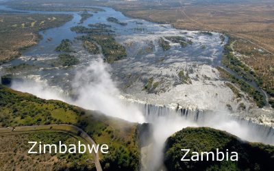
The Zambezi River in southern Africa is home to the spectacular Victoria Falls. The Falls are one of the largest waterfalls in the world, measuring 1,708 m in width. The Zambezi provides a unique habitat to a number of unique plant species. The Falls are located on the border between Zambia and Zimbabwe. To visit Victoria Falls, you must travel to the neighbouring countries of Zambia and Zimbabwe. Listed in the World Heritage List, this site should be on your bucket list.
If you want to see the falls up close, Google Earth has a high-resolution image of the eastern cataract and the Boiling Pot. The path opposite the falls is known as the Knife Edge. The Victoria Falls website offers a comprehensive map portfolio, which features the trail network around the falls, as well as roads and infrastructure. The Kavango-Zambezi Trans-frontier park is expected to be the world’s largest conservation area.
Located on the Zambezi River, the falls were formed by the slow erosion of a soft sandstone cliff face. When the river flows over the edge, it creates a gap so big it can no longer be seen. The Victoria Falls National Park is home to several species of bird and other wildlife, and has recreational facilities to enjoy. In addition, visitors can try bungee jumping, an exciting new way to experience the falls!